D.J. Seo is a University of Texas at Arlington associate professor of civil engineering who has launched a new Android cell phone app called iSeeFlood to encourage the public to file timely reports when they see flooding of varying severity on the streets, in and around their houses, and in streams and creeks. Such flash floods can be dangerous to pedestrians and motorists alike.
The free Google Play app is a new addition to the tool kit that researchers, forecasters and emergency management professionals are using to improve their ability to protect lives and property. An iPhone version is under consideration.
The app will work with the regional Collaborative Adaptive Sensing of the Atmosphere, or CASA, radar system that in recent years has delivered faster, more precise information about severe weather and flash flooding. Seo was instrumental in hosting the first CASA unit in North Texas on top of UTA's Carlisle Hall in 2012.
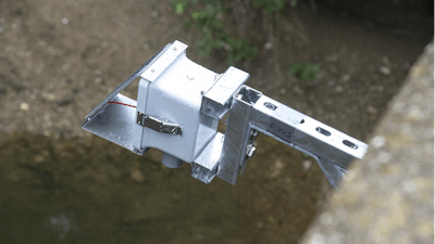
At the same time, Seo's team also has been installing innovative wireless sensors to improve high-resolution modeling of urban water systems. Researchers have started deploying 10 of the high-tech sensors in Fort Worth and Grand Prairie in the first phase of the research. More in Dallas, Arlington and Kennedale are planned in the near future.
"We will integrate the information that people send us using the app and the data from the sensors and the CASA system with flash flood forecasting models," Seo said. "This type of research in real-time sensing and prediction is important particularly because this area is growing fast. Urbanization means we have changing land surface conditions such as increasing impervious land cover, which change how rain may be running off and accumulating."
Greg Waller, service coordination hydrologist for the National Weather Service's West Gulf River Forecast Center, said Seo's work already has advanced the agency's ability to better serve the public and is being shared with agencies like the U.S. Corps of Engineers and U.S. Geological Survey.
"The data helps us calibrate our models, which leads to better forecasts and warnings," Waller said.
Ali Abolmaali, chair of the UTA Civil Engineering Department, said Seo's work illustrates the University's commitment to advancing sustainable urban communities and data-driven discovery under the Strategic Plan 2020: Bold Solutions | Global Impact.
"This is data-driven research with a direct impact on saving lives," Abolmaali said. "The app makes it very easy to report flooding conditions, and we are using sensors to gather additional information in real time. That information is useful not only during floods but in providing guidance on managing water-related hazards in future development."
The iSeeFlood app and the wireless sensors are research outcomes of Integrative Sensing and Prediction of Urban Water for Sustainable Cities, a joint project among The University of Texas at Arlington, University of Michigan and University of Massachusetts Amherst. The project is supported by a $1.2 million National Science Foundation grant Seo received in 2014 to improve sustainability of large urban areas affected by extreme weather, urbanization and climate change through the NSF's Cyber-Innovation for Sustainability Science and Engineering, or CyberSEES, program.