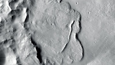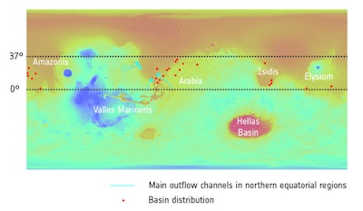
BERLIN (AP) — Scientists say images of Martian craters taken by European and American space probes show there likely once was a planet-wide system of underground lakes.
Researches in Italy and the Netherlands say data collected by NASA and ESA probes orbiting the red planet provide the first geological evidence for a large groundwater system on Mars.
 Topography: NASA/MGS/MOLA; Crater distribution: F. Salese et al (2019)
Francesco Salese, one of the scientists involved, said in an email Friday that the findings confirm earlier models and smaller-scale studies, and that the lakes may have been connected to each other.
Ralf Jaumann, a planetary scientist at the German Aerospace Center who wasn't directly involved in the study, said future Mars landers will be examining the craters for signs of ancient life.
He said large amounts of frozen water may still exist below the surface.
%{[ data-embed-type="image" data-embed-id="5c795f2209fbffbb018b45a4" data-embed-element="span" data-embed-size="640w" data-embed-alt="This diagram shows a model of how crater basins on Mars evolved over time and how they once held water. This model forms the basis of a new study into groundwater on Mars, which found that a number of deep basins – with floors sitting over 4000 m deep – show signs of having once contained pools of water. Images (from the context camera onboard NASA’s Mars Reconnaissance Orbiter) show examples of the different features observed in the basins. There are three main stages: in the first (top), the crater basin is flooded with water and water-related features – deltas, sapping valleys, channels, shorelines, and so on – form within. In the second stage (middle), the planet-wide water level drops and new landforms emerge as a result. In the final stage (bottom), the crater dries out and becomes eroded, and features formed over the previous few billions of years are revealed." data-embed-src="https://img.ien.com/files/base/indm/ien/image/2019/03/example_Evolution_of_water_filled_basins_over_time_node_full_image_2.5c795f22024d2.png?auto=format%2Ccompress&fit=max&w=1280&q=70" data-embed-caption="This diagram shows a model of how crater basins on Mars evolved over time and how they once held water. This model forms the basis of a new study into groundwater on Mars, which found that a number of deep basins – with floors sitting over 4000 m deep – show signs of having once contained pools of water. Images (from the context camera onboard NASA’s Mars Reconnaissance Orbiter) show examples of the different features observed in the basins.<br>
There are three main stages: in the first (top), the crater basin is flooded with water and water-related features – deltas, sapping valleys, channels, shorelines, and so on – form within. In the second stage (middle), the planet-wide water level drops and new landforms emerge as a result. In the final stage (bottom), the crater dries out and becomes eroded, and features formed over the previous few billions of years are revealed." data-embed-credit="Images: NASA/JPL-Caltech/MSSS; Diagram adapted from F. Salese et al. (2019)" data-embed-width="700" data-embed-height="510" ]}%


